The railroads that built Atlanta before the Civil War bypassed Peachtree Road, and it remained an unpaved wagon road for most of its length. The Georgia Air Line Railroad that was chartered in 1856 to connect Atlanta with upstate South Carolina would have changed that, but no track was laid before the war broke out. After the war, the railroad company reorganized and began acquiring right-of-way anew. Grading for the new line began in 1867, but by September 1869, only the first twenty miles were complete. Financial difficulties plagued the company until June 1870 when the Richmond and Danville Railroad acquired the Georgia Air Line Railroad and another small line in South Carolina to form the Atlanta and Richmond Air Line Railway. The first passenger trains between Atlanta and Charlotte ran in September 1873, just as the national economy collapsed into a years-long depression. In 1877, the railroad was reorganized as the Atlanta and Charlotte Air Line Railroad.
The new railroad began at the Georgia Railroad a mile and a half east of Five Points and ran in a northerly direction, crossing Peachtree Creek just downstream from Piedmont Road, and reaching Peachtree Road near its intersection with N. Druid Hills Road. There it turned to the northeast and ran along Peachtree Road through DeKalb and Gwinnett Counties on its way to Gainesville. Eleven grade crossings were created from Duluth to Brookhaven, beginning a process of fragmentation and renaming that destroyed the continuity of the old war road. By the 1890s, New Peachtree Road was created on the southeast side of the railroad by connecting segments of the old road on that side of the track into a continuous road from Brookhaven to Gwinnett County.
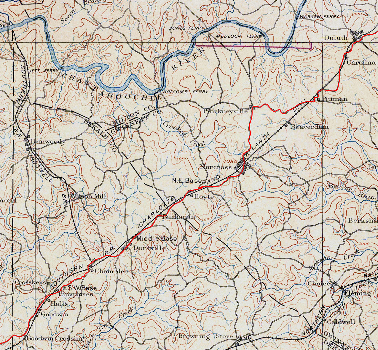 Figure 1. Detail from USGS topographical map, 1895, showing the Airline Railroad between what are now Brookhaven, lower left, and Duluth, upper right, annotated by the author to highlight in red the route of old Peachtree Road. Figure 1. Detail from USGS topographical map, 1895, showing the Airline Railroad between what are now Brookhaven, lower left, and Duluth, upper right, annotated by the author to highlight in red the route of old Peachtree Road. |
For “air line” railroads, a level, direct route was the aim, and the cost of bridging a waterway or tunneling a ridge was seldom prohibitive. As a result, although the new railroad generally followed the high, relatively level route of Peachtree Road between Duluth and Brookhaven, bridges carried the railroad directly across the headwaters of Beaver Ruin Creek, thus bypassing the 1814 road’s circuitous route around them and shortening travel between Norcross and Duluth by over a mile. Foot and wagon traffic would continue along the old road until Buford Highway followed the more direct route of the railroad when that highway was built in the 1930s.
The Air Line Railroad spawned a series of whistle stops all along the way and gave rise to four small towns that would be nodes for suburban growth of Atlanta in the twentieth century. In 1869 John J. Thrasher (1818–1899), who had been one of the early pioneers in Atlanta but grown disgusted with its politics, bought 250 acres around the intersection of Peachtree and Holcombe Ferry, now Holcombe Bridge, Roads in western Gwinnett County where the new railroad would run. With a general store and a few residences, the settlement became the second incorporated town in the county in 1870, although the railroad was still months away from completion. Thrasher named it for his old friend and ex-Atlanta mayor Jonathan Norcross (1808–1898), who had also been president of the erstwhile Georgia Air Line Railroad.
The next year, two more towns were incorporated, one six or so miles to the northeast of Norcross and another about five miles to the southwest. To the northeast, in 1833 Evan Howell (1782–1868), one of a large family that would have a major role in shaping the growth of Atlanta, established a ferry on the Chattahoochee River near his home and opened a road connecting it to Peachtree Road. With the arrival of the railroad, Howell’s Crossing, as the intersection of roads had been known, was incorporated as Duluth in 1871. It is not clear why that name was chosen.
That same year, Doraville was incorporated. Only eleven miles from downtown Atlanta, the town had general and dry goods stores that made it the commercial center for the surrounding agricultural community. All three towns used some segments of the old war road and bypassed or abandoned others, but echoes of the route of the original road remain in each town, especially in Duluth, where there was commercial activity along the route of the old war road even before the coming of the railroad.
In 1881 a narrow-guage railroad was built to connect the mills at Roswell with the Air Line Railroad which it joined at a point just a half mile south of Peachtree Road’s intersection with Shallowford Road, which was itself an important early road that also ghosted the route of an ancient trail. Prospect Methodist-Episcopal Church built a log church on Peachtree Road just west of that intersection in 1828, and Prosperity Presbyterian Church built on the east side not long after it was organized in 1836. Today only the cemetery remains on the site of the Presbyterian church, just west of the historic road intersection. The third Prospect Church building (ca. 1885) and that church’s cemetery remain on Peachtree Road at the heart of Chamblee.
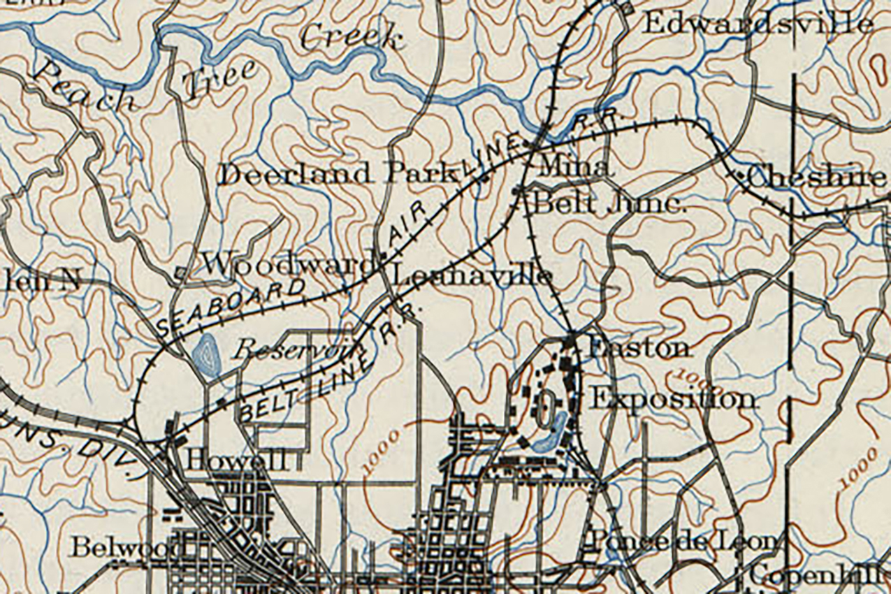 Figure 2. Detail from USGS topographical map, showing where the Belt Line Railroad and the Seaboard Air Line Railroad passed under Peachtree Road. Figure 2. Detail from USGS topographical map, showing where the Belt Line Railroad and the Seaboard Air Line Railroad passed under Peachtree Road. |
The place was known as Roswell Junction and a general store, a depot, and worker housing joined the old churches there in the 1880s. A post office was established in 1908 but, fearing confusion with the post office at Roswell, the new office was named Chamblee, which was apparently one of several names submitted. The city’s motto today is “A City on the Right Track.”
Just east of the Prosperity Church cemetery, the Air Line Railroad crossed Peachtree Road at an oblique angle that still allowed for a grade crossing, But when the single pair of rails became ten with construction of the new General Motors assembly plant at Doraville in 1947, the grade crossing was eliminated entirely. A new road, still bearing the name Peachtree Road, turned north at the old railroad crossing to connect with the new Peachtree Industrial Boulevard that was built as a bypass of downtown Chamblee.
In 1889–90, the Atlanta and Charlotte Air Line Railroad joined the Georgia Pacific Railroad in building the Belt Line Railroad to connect their two lines three miles north of downtown. Running from near the present intersection of I-85 and Monroe Drive to an intersection with Inman Yards near the city waterworks on Howell Mill Road, the Belt Line Railroad completed what is now the track used by Amtrak. Construction included a deep cut under Peachtree Road. In 1892, congestion on the Belt Line provoked the Seaboard Air Line Railroad to build a second line, which also cut through Peachtree Road, but not as deeply, a mile or so north of the first cut. The wooden bridges that carried Peachtree Road across the railroad cuts were nuisances for the increasing flow of traffic to suburban development on the north side of the city until the Peachtree Road bridges over the railroad and the creek were replaced with reinforced-concrete in 1907.
![]()
This and associated web pages are an expanded version of a paper presented at the Preserving Historic Roads Conference 2014 in Savannah, Georgia. They are presented here for your amusement and edification and not for commercial use. Tommy H. Jones, Atlanta Georgia, December 2020. |
![]()